

Google Maps Offline Directions Review
About a month ago I covered Google’s announcement of the release of turn by turn directions for Google Maps online. (Android only right now. Coming to iOS soon.) At that time I was only a few days away from my Panama trip, so I was hoping to get the new version of the app. Thankfully it came to my device the morning I took off and I was able to test this functionality on my way to/from the Panama Canal, my hotel and the airport.
How to Download Offline Maps
Before I detail my experience, let’s look at how to download the offline maps. Google has made it incredibly easy.
- To download an offline map, simply search for the city/area in Google Maps and go to the destination page that comes up. For example, here is my search for Panama.
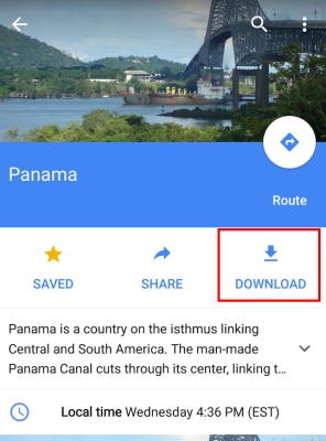
- Unlike previously, you don’t have to mess with menus or anything else. Once you reach this screen simply hit “Download” and it will ask you to choose the area.
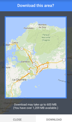
- You can zoom in or out with your fingers and the app shows you how much space your map will take and how much you have available. Once you have the correct region, then click “Download” and the fun begins!
My Panama Google Maps Experience
I was down in Panama with PDX Deals Guy to complete the AAdvantage Elite Fast Track. We agreed that I would be the driver and he would be the navigator. Since I recently changed from T-Mobile to AT&T I didn’t have international data, so this really came in handy. After landing and procuring the rental car, I typed in Panama Canal into the search box and Google Maps calculated a route. That was a good sign!

As we left the airport, I immediately noticed there is one huge difference with the offline system. Since voice data would make the map too big, it simply dings at you whenever you are supposed to turn. This isn’t terrible if you have a navigator, but it could be hard when you are buy yourself. With that said, the full street names and directions do show on the screen.
Getting to the Canal
Panama City has a lot of streets that suddenly split and wrap around each other. Navigating through these was tough, even with the GPS directions. Several times we almost went the wrong way, but managed to correct it at the last minute. Then, at one point we did go the wrong way and Google Maps flawlessly redirected us. I’m not honestly sure a normal GPS would have done any better.
About 40 minutes after we left, we arrived at the parking lot of the Miraflores Locks on the Panama Canal! We watched the movie, looked through the museum and then waited until a ship came through the locks. It was supposed to rain, but thankfully the weather held up. As you might expect the ship moved slowly, but eventually it went from one side to the other.

Getting to Our Hotel
Getting from the Canal to the hotel was quite a bit easier. We had already driven about 90% of the route on the way out to the canal, so it was more familiar. Still, at one point the road split and we didn’t know which way to go. Luckily I made a last minute decision to go left and I was right! Lucky for once I guess.
Before long we did arrive safely at the beautiful Hyatt Place Panama City. This hotel is definitely nicer than the U.S. Hyatt Places and almost could be a normal Hyatt. The rooms were great and the hotel was comfortable. Most importantly, they have free valet parking so the car is nice and safe overnight.

Back to the Airport
Our final test of Google Maps offline came as we drove back to the airport. We had an early morning flight, so we left the hotel at around 5am. Without traffic to deal with, the instructions were easier to follow and we got to our destination without any hassle. My phone truly did a fantastic job navigating without the internet connection. This is the death blow to dedicated GPS systems in my opinion.
Overall Thoughts
I actually think Google Maps offline is more important than most people know. Maps & GPS can use up a lot of data and now having that information stored locally should help with that. While this is a useful international driving tool, it is probably going to be just as useful for when you are at home. Even if you have an internet connection, why should you suck all of your data when you can simply download a map?
Conclusion
I was beyond impressed with Google Maps Offline turn by turn directions and can’t wait to see how they improve the functionality. While we did have a few hiccups, they were mostly caused by the confusing roads of Panama City. Sure, having a voice to guide us would probably have helped, but it wasn’t necessary and we were able to get around without a connection. How awesome!
Lower Spend - Chase Ink Business Preferred® 100K!
 Chase Ink Business Preferred® is a powerful card that earns 3X Ultimate Rewards points in a broad range of business categories on the first $150K in spend per year. Right now earn 100K Chase Ultimate Rewards points after
 Learn more about this card and its features!
Opinions, reviews, analyses & recommendations are the author’s alone, and have not been reviewed, endorsed or approved by any of these entities.


Shawn, do you remove comments? I just posted one that (nicely) said that Here maps is a better choice than Google Maps and it was here but now it’s gone.
Hmmm…
scratch that….it’s back. (What’s going on?)
Not sure what is going on. I didn’t touch it. When I looked on Mobile it didn’t show, but it is here on the desktop. WordPress caches content a lot of the time, so my guess is that you saw a cached version that wasn’t updated. I never delete comments unless they contain abusive or profain language.
Thanks for the tip on Here Maps by the way. I’ll make sure to test it out on my next trip. I have heard of it, but never preferred the look of Nokia’s maps. Sounds like I need to give them another look.
Here Maps has been around for a long time (made by Nokia), and offers downloadable maps by country and state, which is far better than Google’s “download area” method. In addition, Here has voice guided directions, offers walking and public transport options, etc.
One more cool thing: if you download the states that you know you’ll be flying over, you can track where you are during a flight and point out features on the ground below!
I’ve used both but Here Maps is far better.
Missed turn? Must have been driver error. Couldn’t have been the navigator.
I wouldn’t call this a game changer especially when it’s not flawless. There are already plenty of better offline map apps for both Android and iOS.
Shawn – One thing you did not discuss was after the trip (or the downloaded map is not longer needed, for any reason) how does one delete the map and free up some phone memory?
The answer is here:
1. Open the Google Maps app
2. Touch the Menu icon
3. Choose Offline areas
4. Select a place
5. Touch delete
I love this and am looking forward to trying this out in northern Costa Rica in a few days where the navigable roads are few and traffic signs even rarer!
Just get T-Mobile or sprint dude. Problem solved.
I had T-Mobile and it really stinks in my area. AT&T paid me $1700 to switch so I am not going to turn down over a year of free service. That really isn’t the point of this anyway. Cell service isn’t always reliable, especially in foreign countries. Even if you have data, you may not have a good enough connection.
This question may show how dumb i am, but how does the GPS tracker know your position if you have data turned off?
Most smartphones built in the past few years have their own dedicated GPS chip that talks to the satellites without the need for a connection. It works the same as a standalone GPS device.
Great to know. I love the freedom of a car when travelling. I find apple maps are way worse in Central n S America. I use Google maps exclusively. Do i need to download a new app?
It will come as an update, but it is only on Android right now. They promised to have iOS support “soon”.
I agree that this is great as an international driving tool.
I was disappointed to learn that it does not support offline public transit directions. I don’t know how big that database would be, but phone storage is pretty big these days.
When I was in Japan I was completely reliant on public transit directions from Google. Fortunately free public wifi was publicly available in the cities I visited.
That is a limitation. This is their first version of offline directions, so hopefully it will get better and they will be able to add that information in. I think a lot of transit directions has to do with times which may not be correct if you are offline, but hopefully they can at least give you the proper route, etc.
Yeah hopefully it’s coming.
The timing of transit directions shouldn’t be too hard though. Most public transit timetables are on repeating on a weekly basis. Even if they just assumed that there were no special conditions, such as holidays, and displayed that (with a disclaimer it might not be accurate for holidays), that’d be great.
And like you said, even without timing, the route itself would be helpful.
That is a limitation. This is their first version of offline directions, so hopefully it will get better and they will be able to add that information in. I think a lot of transit directions has to do with times which may not be correct if you are offline, but hopefully they can at least give you the proper route, etc.
What version do I need, I only have save and share not download.
It should be fully rolled out to Android devices, so just go into the Google Play Store and check for an update. If you are on iOS, they still haven’t released this functionality.